Revealing maps and information about our world
If you see the Earth as a planisphere, then these 40 maps below will change your view of things. From world population figures to unusual data to informative information, you may get answers to questions you sometimes ask yourself, or, on the contrary, it will raise questions. One thing is certain, these maps tell us more about the world we live in.
1. Map of countries where Google Street View is available (2014)

2. Map of countries that have not officially adopted the metric system (in red)

3. The only 22 countries in the world that England has never invaded (in white)

4. Map of Pangaea with current boundaries

Pangaea was a unique 'supercontinent' that existed at the end of the Paleozoic (Primary Era) and then separated 200 million years ago to form the Earth as we see it today.
5. Map of where McDonald's is located around the world

The map shows the countries where you can find a McDonald's restaurant (in red). In blue where the American firm is not. Next, the number of McDonald's restaurants per country is shown on the bottom left and the highest price for a McDonald's burger is shown on the bottom right.
In the red box it says: "The largest (over 28,000 square meters) and most popular (over 250 million customers since opening) McDonald's restaurant in the world is located on the famous Pushkin Square in Moscow. The restaurant has 700 seats and has a 22-meter long counter and 27 cash registers. »
6. Map of paid maternity leave around the world

Dark blue: 26 weeks and over, blue/grey: 14-25 weeks, light blue: less than 14 weeks. Red: unpaid
7. Map of the most common surnames in each European country

8. Map of the direction of traffic in the world (blue: left, red: right)

9. Map of time zones in Antarctica

10. Map of global Internet usage by time of day

11. Map of the 10 busiest air corridors in 2012

In millions of passengers
12. Map analyzing population density in the world

"There are more people living inside that circle than outside it."
13. Map of world flags

14. Map of world alcohol consumption in litres

Consumption per adult over 15 years of age, in litres of pure alcohol for the year 2005
15. Map of the most popular alcoholic beverages by country

Most consumed alcoholic beverages, in litres of pure alcohol for the year 2005 (beer, wine, spirits, other)
16. Map of rivers in the United States

17. U.S. Public Service Top Paid Employees Card by State

A career as a football coach seems to be a job that pays well...
18. Map of earthquakes around the world since 1898

19. Map of corruption in the world

According to the James Mintz Group, countries with a dark red colour are the most corrupt countries in the world, with bribes of up to $1.70 billion.
20. Map of vegetation on Earth

21. Map of the age of first sexual intercourse in the world (15-23 years)

22. If the world's population lived at the density of a single city...

Computer graphics show, at the time when we were 6.9 billion people on Earth, that if we lived in a city with the density of Paris, New York, London etc... it would represent the different colours on the map of the United States. The author of this computer graphics then adapted this data to the whole Earth and according to the countries (see the result here).
23. Map of the number of researchers per million inhabitants in the world

The Scandinavian countries, the United States, Japan, and Australia seem to have many researchers among their citizens.
24. World map of oil exports and imports in 2011 in million tonnes

25. Map of the 7000 rivers that feed the Mississippi River

26. World map of the different alphabets

27. Map of annual coffee consumption in kilograms per person

28. 28. If the world were divided into seven regions, each with a population of 1 billion people

29. World population in latitude and longitude in 2000

30. Map of the United States superimposed on the Moon

31. Frequency of lightning strikes around the world

32. Map of drinking and non-drinking water in the world

In red, the water has a high risk of being infected. Source: World Resources Institute
33. Only 2% of Australians live in the yellow part.

34. Map of translations of the word "beer" in Europe

35. Map of press freedom in the world in 2014

Source : Reporters Without Borders
36. Map of the most welcoming (red) and inhospitable (sky blue) countries

37. World map of most used Internet browsers in 2014

Source: Stat Counter
38. Map of the most popular sports in the world

39. Map of the prevalence of obesity in the world

Source: Harvard
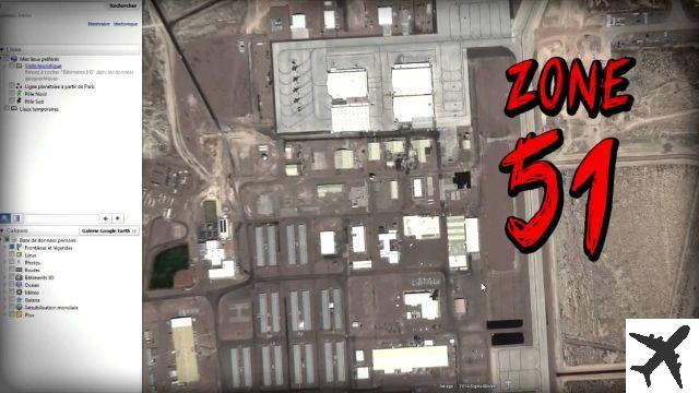
40. World map of nuclear sites

These world maps make you react? Comment and share!